The top 25 sights in the USA
21. Canyonlands National Park
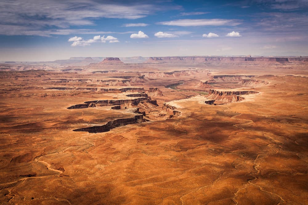
Canyonlands National Park is located in eastern Utah, just 70 kilometers from Moab, which should be the starting point for a visit to Canyonlands. Canyonlands National Park is particularly worth a visit due to its enormous canyons, which are reminiscent of a variation of the Grand Canyon and through which the Colorado River meanders. The numerous viewpoints in particular are worth the drive, but good hikers also get their money’s worth from time to time.
Canyonlands National Park consists of two sections, which can be a little confusing at first: To the north is the Island in the Sky District, which you should head for from Moab and near which you will also find Dead Horse Point State Park with its wonderful views of the Colorado River. A little further south is the Needles District, which you should visit on the onward journey to Monument Valley (or vice versa) and which takes a whole day to explore.
As usual, the first thing you should do after entering the Island in the Sky District is stop at the Visitor Center and enjoy the wonderful Grand View Point and the Green River Overlook, two great viewpoints of the breathtaking canyons of Canyonlands.
In the Needles District, we recommend the Spring Canyon Overlook and the drive up to Elephant Hill, from where you have a view of the eponymous Needles. There are many small hiking trails in this area, which you can follow at your pace and interest without spending too much time.
As is so often the case, consider the weather: in summer, it gets damn hot in Utah and even supposedly short hikes can be a pain in the neck – on the other hand, sudden heavy rain and severe thunderstorms are not uncommon, especially in spring and fall. In the northern district, you will almost always meet other visitors, while the Needles section is quieter.
Hiking trails in Canyonlands National Park
Highly recommended on the island in the Sky District are the short hikes (about 1–2 kilometers each) to Mesa Arch, a bright arch — unlike in Arches NP — and to Upheaval Dome. There are a number of longer recommended hiking trails, but they take more than a day and are therefore only recommended for hikers with tents.
The very brave can take on the Chesler Park Loop Trail in the Needles District, which is 18 kilometers long and leads past several great viewpoints. The trail is primarily recommended for backpackers — and only with sufficient water and food and in small groups.
Canyonlands: Where to stay overnight?
There are two small campsites for motorhomes in both the Island in the Sky and the Needles District. The usual place to stay is therefore Moab, which is also the starting point for Arches National Park and offers numerous motels, hotels and campsites. As the only real town within a radius of hundreds of kilometers, Moab also offers almost everything you need, including large supermarkets and several fast food chains.
Ad
22. Empire State Building (New York)
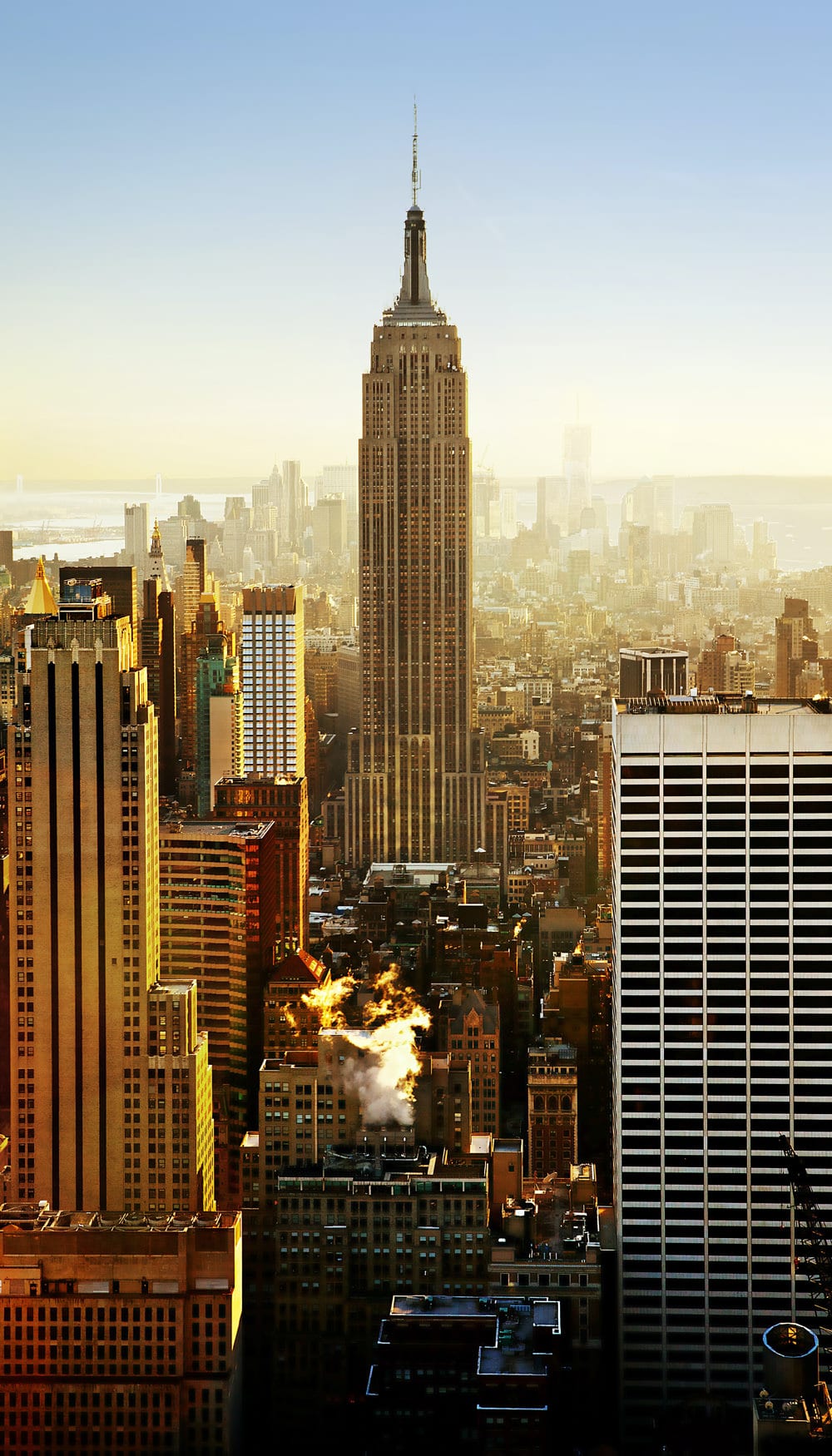
The Empire State Building — one of the most famous landmarks in New York and the entire USA — is a 102-storey Art Deco skyscraper in Midtown Manhattan in New York City. It was designed by Shreve, Lamb & Harmon and built from 1930 to 1931. Its name is derived from Empire State, the nickname of the state of New York. The building has a roof height of 380 m and is 443.2 m high in total, including the antenna. The Empire State Building was the world’s tallest building until the World Trade Center was built in 1970; after its collapse in 2001, the Empire State Building was once again the city’s tallest skyscraper until 2012. As of 2020, the building will be the seventh-tallest building in New York City, the ninth tallest completed skyscraper in the United States, the 49th tallest in the world and the sixth-tallest freestanding building in America.
The site of the Empire State Building in Midtown South on the west side of Fifth Avenue between West 33rd and 34th Streets was built in 1893 as the Waldorf-Astoria Hotel. In 1929, Empire State Inc. acquired the site and drew up plans for a skyscraper. The design for the Empire State Building was changed fifteen times until it became the world’s tallest building. Construction began on March 17, 1930, and the building opened thirteen and a half months later, on May 1, 1931. Despite the positive publicity associated with the construction of the building, the owners did not make a profit until the early 1950s due to the Great Depression and the Second World War.
The building’s art deco architecture, height, and viewing platforms have made it a popular attraction. Around four million tourists from all over the world visit the observatories on the 86th and 102nd floors of the building every year; an additional covered observatory on the 80th floor was opened in 2019. The Empire State Building is an American cultural icon: since the movie King Kong in 1933, it has been featured in more than 250 TV shows and films. The size of the building has become the global standard for describing the height and length of other structures. The building is a symbol of New York City and was named one of the Seven Wonders of the Modern World by the American Society of Civil Engineers. In 2007, the American Institute of Architects ranked it first on its list of America’s favorite architecture. Similarly, the Empire State Building and its first floor interiors were designated a city landmark by the New York City Landmarks Preservation Commission in 1980 and added to the National Register of Historic Places as a National Historic Landmark in 1986.
How to find the Empire State Building
The Empire State Building is located on the west side of Fifth Avenue in Manhattan, between 33rd Street to the south and 34th Street to the north. Tenants enter the building through the Art Deco lobby at 350 Fifth Avenue. Visitors to the Observatories use an entrance at 20 West 34th Street; before August 2018, access was through the Fifth Avenue lobby. Although the building is located in South Midtown, a mixed residential and commercial neighborhood, it is so large that it has been assigned its zip code.
There are other important sights near the Empire State Building, including
- Macy’s at Herald Square on Sixth Avenue and 34th Street,
- Koreatown on 32nd Street between Madison and Sixth Avenues,
- Penn Station and Madison Square Garden on Seventh Avenue between 32nd and 34th Streets,
- and the Flower District on 28th Street between Sixth and Seventh Avenues.
The closest New York City Subway stations are 34th Street-Penn Station at Seventh Avenue, two blocks west; 34th Street-Herald Square, one block west; and 33rd Street at Park Avenue, two blocks east. There is also a PATH station at 33rd Street and Sixth Avenue.
To the east of the Empire State Building is Murray Hill, a neighborhood with a mix of residential, commercial and entertainment activities. On the block directly to the northeast is the B. Altman and Company Building, which houses the Graduate Center of the City University of New York, while the Demarest Building is directly across Fifth Avenue to the east.
Ad
23. Lombard Street (San Francisco)

Lombard Street is an east-west street in San Francisco, California, known for a steep, one-block stretch with eight hairpin turns. It extends from the Presidio east to the Embarcadero (with a gap at Telegraph Hill). Most of the western section of the road is a major highway, designated as part of U.S. Route 101. The famous one-block section, claimed to be “the world’s steepest road,” is located along the eastern section in the Russian Hill neighborhood. It is a major tourist attraction with around two million visitors a year and up to 17,000 visitors a day on busy summer weekends. Surveyor Jasper O’Farrell from San Francisco named the street after Lombard Street in Philadelphia.
The western end of Lombard Street is at Presidio Boulevard; from there it heads east through the Cow Hollow neighborhood. Between Broderick Street and Van Ness Avenue, it is a major thoroughfare for 12 blocks, co-signed as U.S. Route 101. Lombard Street continues through the Russian Hill neighborhood and to the Telegraph Hill neighborhood. In Telegraph Hill, it turns south and becomes Telegraph Hill Boulevard, which leads to Pioneer Park and Coit Tower. It begins again at Winthrop Street and ends at the Embarcadero as a collector street.
Lombard Street is known for the one-way block on Russian Hill between Hyde and Leavenworth Streets, which is considered the steepest street with its eight sharp curves. The design, first proposed by property owner Carl Henry and built in 1922, was intended to reduce the hill’s natural 27 percent gradient, which was too steep for most vehicles. The steep block is about 180 meters long, leads in only one direction (downhill) and is paved with red bricks. The sign at the top recommends a speed of 5 mph (ca. 8 km/h).
The section is normally used by around 250 vehicles per hour, with average daily traffic reaching around 2,500 vehicles per year. At peak times, vehicles may have to wait up to 20 minutes to enter the Crooked Street section, with the queue stretching as far as Van Ness Avenue. To alleviate the usual congestion and delays, visitors may be asked to reserve a time and pay a fee to drive down Crooked Street.
The Academy of Art University owns and operates a building on the street called Star Hall, which serves as a residence. Former residents of Lombard Street include Rowena Meeks Abdy, an early Californian painter who worked in the Impressionist style. Chase scenes in many films were shot in the street. Lombard Street can also be seen in the 2015 Pixar film Inside Out.
Ad
24. Mount Rushmore National Memorial (South Dakota)
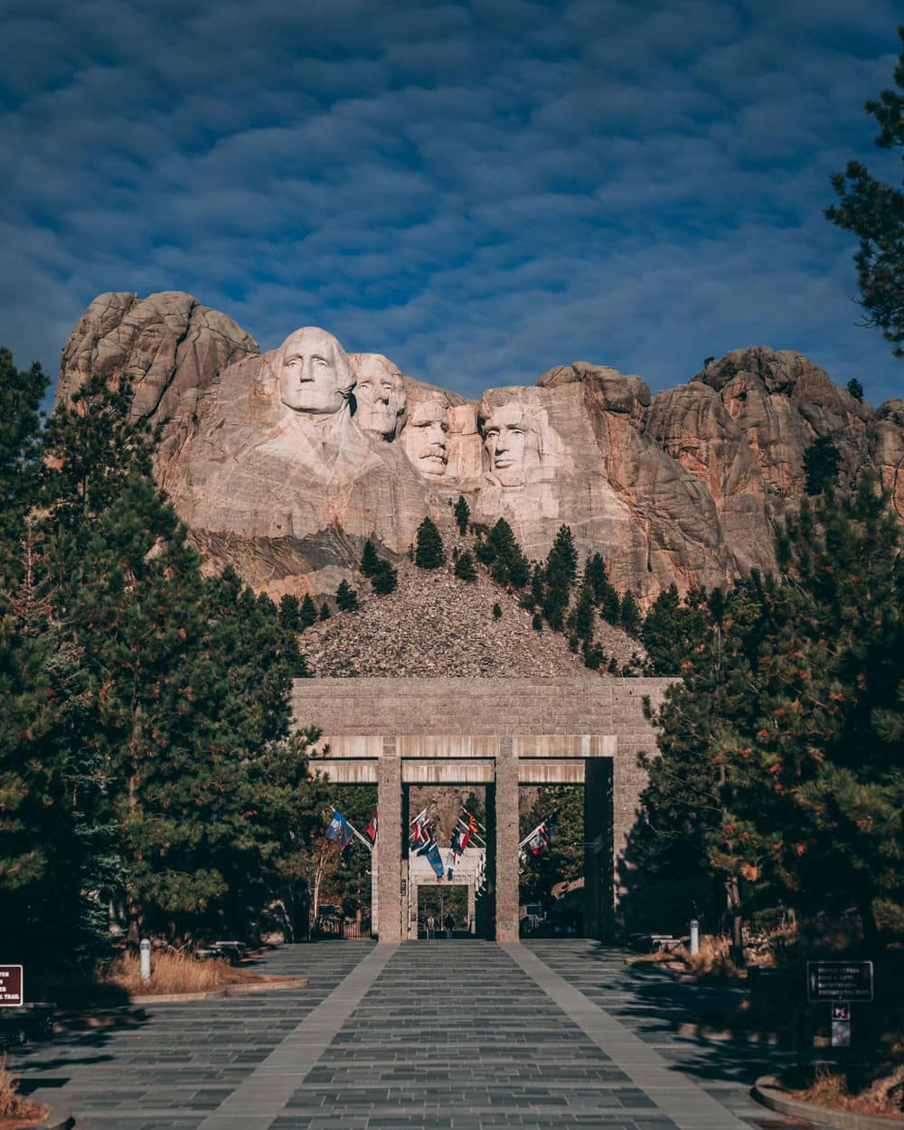
At the center of the Mount Rushmore National Memorial is a colossal sculpture carved into the granite face of Mount Rushmore. The sculptor Gutzon Borglum designed the sculpture and oversaw the execution of the project from 1927 to 1941 with the help of his son Lincoln Borglum.
The sculpture depicts the 18-meter-tall heads of Presidents George Washington (1732-1799), Thomas Jefferson (1743-1826), Theodore Roosevelt (1858-1919) and Abraham Lincoln (1809-1865), as proposed by Borglum. The four presidents were chosen to represent the birth, growth, development, or more specifically, the preservation of the nation. The memorial park covers 5.17 km², the actual mountain is located at an altitude of 1,745 m above sea level.
The sculptor and the tribal representatives agreed on Mount Rushmore, which also offered the advantage of facing southeast and thus being optimally exposed to the sun. Robinson initially wanted the sculpture to depict heroes of the American West such as Lewis and Clark, their expedition leader Sacagawea, the Oglala Lakota chief Red Cloud, Buffalo Bill Cody and the Oglala Lakota chief Crazy Horse. Borglum was convinced that the sculpture should have a broader appeal and chose the four presidents.
Peter Norbeck, US Senator from South Dakota, supported the project and secured federal funding. Construction began in 1927; the faces of the presidents were completed between 1934 and 1939. After Gutzon Borglum died in March 1941, his son Lincoln took over management of the construction project. Originally, each president was to be depicted from head to waist, but due to a lack of funds, construction had to be halted on October 31, 1941.
Mount Rushmore is sometimes referred to as the “shrine of democracy” and attracts well over two million visitors every year.
Visitor Center
Harold Spitznagel and Cecil Doty designed the original visitor center, which was completed in 1957. These buildings were part of Mission 66 to improve visitor facilities at national parks and monuments across the country. Ten years of redevelopment culminated in 1998 with the completion of extensive visitor facilities and walkways, including a visitor center, the Lincoln Borglum Museum and the Presidential Trail. Maintenance of the memorial requires climbers to monitor and seal the cracks annually. Due to budget constraints, the memorial is not regularly cleaned to remove lichen. On July 8, 2005, Alfred Kärcher, a German manufacturer of pressure washing and steam cleaning machines, conducted a free, multi-week cleaning operation using pressurized water at a temperature of over 93 °C.
On October 15, 1966, Mount Rushmore was added to the National Register of Historic Places. A 500-word essay by Nebraska student William Andrew Burkett on the history of the United States was selected as the winner of a group of students in a 1934 contest, and this essay was placed on a bronze plaque at the Entablature in 1973. In 1991, President George H. W. Bush officially dedicated Mount Rushmore.
Suggestions for adding more faces
In 1937, when the sculpture had not yet been completed, a bill in Congress to add women’s rights activist Susan B. Anthony. When the sculpture was completed in 1941, the sculptors declared that the remaining rock was not suitable for additional carvings. This view was shared by RESPEC, an engineering firm hired in 1989 to monitor the rock’s stability. Nevertheless, suggestions were made for further sculptures. These included John F. Kennedy after his assassination in 1963 and Ronald Reagan in 1985 and 1999 — with the latter proposal being debated in Congress at the time. Barack Obama was asked about his possible addition in 2008 and joked that his ears were too big.
Tourism
Tourism is the second-largest industry in South Dakota, and Mount Rushmore is the state’s top tourist attraction. In 2012, 2,185,447 people visited the park. In the 1950s and 1960s, local Lakota Sioux elder Benjamin Black Elk (son of medicine man Black Elk, who participated in the Battle of Little Bighorn) was known as the “Fifth Face of Mount Rushmore”. He posed daily in his Native American costume for photos with thousands of tourists. The South Dakota State Historical Society noted that he was one of the most photographed people in the world during this twenty-year period.
Hall of Records
Borglum originally planned a great hall of records, where America’s most significant historical documents and artifacts would be protected and displayed to tourists. He succeeded in getting the project off the ground, but was only able to cut 21 meters into the rock before work was halted in 1939 to focus on the faces. To complete Borglum’s vision, a depository was built inside the cave entrance in 1998, containing 16 enamel plaques with biographical and historical information about Mount Rushmore, as well as the texts of the documents Borglum intended to keep there. The vault consists of a teak box (housing the 16 tablets) set in a titanium vault embedded in the floor with a granite capstone.
Ad
25. Mammoth Cave National Park
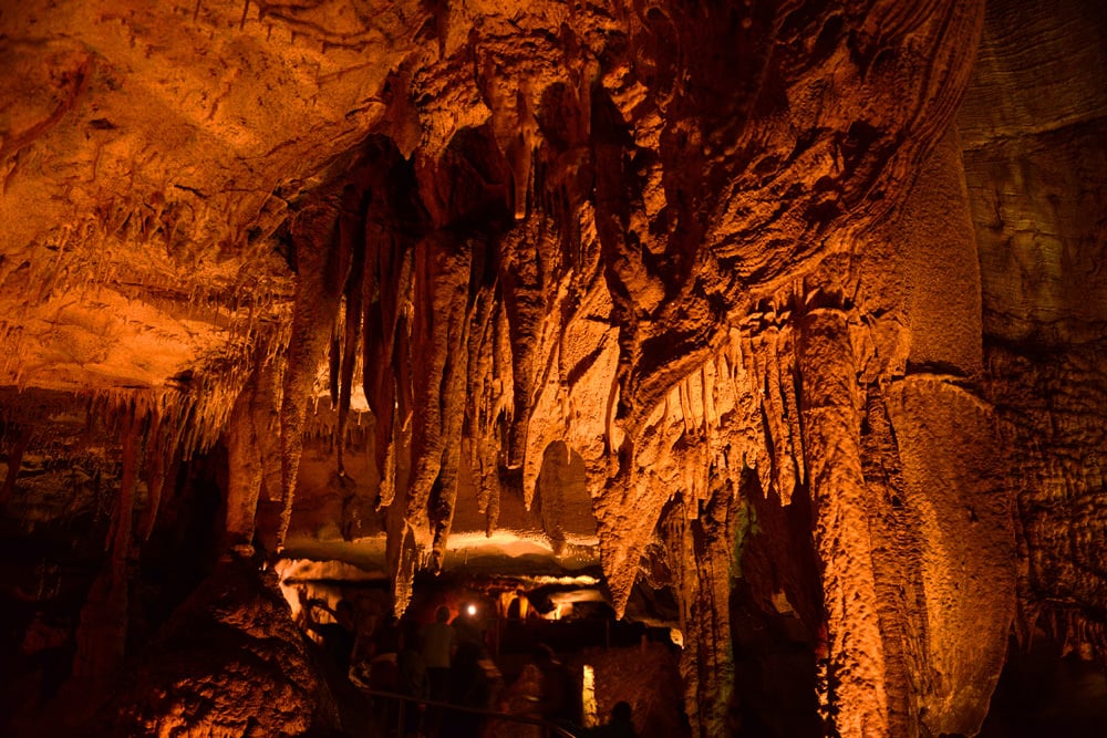
Mammoth Cave National Park is an American national park in west-central Kentucky that includes parts of Mammoth Cave, the longest known cave system in the world. Since Mammoth Cave was merged with the even longer system under Flint Ridge to the north in 1972, the official name of the system has been the Mammoth-Flint Ridge Cave System. The park was designated a National Park on July 1, 1941, a World Heritage Site on October 27, 1981, an International Biosphere Reserve on September 26, 1990, and an International Dark Sky Park on October 28, 2021.
The park’s 521,380 acres are located primarily in Edmonson County, with small areas extending east into Hart and Barren counties. The Green River flows through the park, and a tributary called the Nolin River joins the Green River directly in the park. Mammoth Cave is the longest known cave system in the world with more than 680 km of surveyed passages, almost twice as long as the second-longest cave system, the Mexican underwater cave Sac Actun.
Purpose of the park
The purpose of Mammoth Cave National Park is to preserve, protect, interpret and study the internationally recognized, biological and geological features and processes associated with the world’s longest known cave system, the park’s diverse forested karst landscape, the Green, and Nolin Rivers and the extensive evidence of human history, and to provide and promote public enjoyment, recreation and understanding.
Mammoth Cave has developed in thick layers of Mississippian limestone overlain by a layer of sandstone, which has made the system remarkably stable. It is known to contain more than 640 kilometers of passageways, with new discoveries and connections adding several miles each year. Mammoth Cave National Park was established to protect the cave system.
The upper sandstone layer is known as the Big Clifty Sandstone. Thin, sparse layers of limestone within the sandstone form an epikarstic zone where tiny veins (cave passages too small to enter) are dissolved by the natural acidity of the groundwater. The epikarstic zone concentrates the local runoff streams in high-altitude springs that emerge at the edges of the mountain ridges. The water from these springs usually flows briefly on the surface before sinking back underground at the level of contact between the sandstone and the underlying massive limestones. The region’s caves, which can be explored by humans, have developed naturally in these underlying massive limestone layers.
Each of the primary limestone layers is further subdivided into named geological units and subunits. One area of cave research is to correlate the stratigraphy with the cave register created by the researchers. In this way, approximate three-dimensional maps of the contours of the various layer boundaries can be created without the need for test drilling and core sampling.
The upper sandstone layers are relatively difficult for water to penetrate: The exceptions are vertical cracks. This protective function means that many of the older, upper passages of the cave system are very dry, with no stalactites, stalagmites or other formations that require flowing or dripping water to develop.
However, in many places in the park, such as the Frozen Niagara area, the sandstone cap has been dissolved and eroded. The contact between limestone and sandstone can be seen on a hike from the valley bottoms to the ridges: As you approach the top of a ridge, you can typically see how the composition of the exposed rock changes from limestone to sandstone at a well-defined height.
A giant sinkhole has formed in the bottom of a valley in the southern region of the park. The sinkhole, known as Cedar Sink, has a small river that enters on one side and disappears underground on the other.
Offers for tourists
The National Park Service offers several cave tours for visitors. Some notable features of the cave, such as Grand Avenue, Frozen Niagara and Fat Man’s Misery, can be viewed on lighted tours that last between one and six hours. Two tours, lit only by kerosene lamps carried by visitors, are popular alternatives to the electric-lit routes. Several “wild” tours lead away from the developed parts of the cave into muddy crawlways and dusty tunnels.
The Echo River Tour, one of the cave’s most famous attractions, took visitors by boat along an underground river. The tour was discontinued in the early 1990s for logistical and environmental reasons.
The Mammoth Cave headquarters and visitor center are located on the Mammoth Cave Parkway. The parkway connects Kentucky Route 70 in the north and Kentucky Route 255 in the south with the park.
Ad
Note: Links marked with an asterisk (*) or “Ad” are so-called affiliate links. As an Amazon partner, we earn from qualified sales. The same applies to other partners. This means that we receive a small commission on purchases or bookings to finance this site. There are no additional costs for you!


